وبلاگ دکتر علی کلانتری اسکوئی
وبلاگ علمی،آموزشی و خبری در رابطه با سامانه اطلاعات مکانی(GIS)وبلاگ دکتر علی کلانتری اسکوئی
وبلاگ علمی،آموزشی و خبری در رابطه با سامانه اطلاعات مکانی(GIS)
About Landsat 8
Landsat 8 was launched February 11, 2013, and contains two sensors. One collects 8-band multispectral imagery at 30-meter resolution as well as panchromatic imagery at 15 meters. The other collects thermal imagery at 100-meter resolution. The orbit of the satellite results in its capturing 170-by-185-kilometer sized scenes along
a predefined path that returns to the same location every 16 days.
Ref:
,Esri News
for Map, Chart & Data Production Summer 2014
دستور IF اکسل و روش دومارتن
استفاده از IF های تودرتوی Excel، در بحث تصمیگیری ها، باعث افزایش دقت و سرعت می گردد، لذا این یاداشت را نوشتم همراه با یک مثال موردی یعنی کاربرد روش دومارتن درپهنه بندی اقلیمی .
در مجموع روش کار با IF های تودرتو در تمام مطالعات مشابه است فقط عناوین کلاس ها و یا معیارها تغییر می کنند.
******************************************************
کتابی در رابطه با پایان نامه نویسی
دانلود کتاب(به زبان انگلیسی- حدود 1.9 مگا)
*******************************************************
معرفی Whitebox Geospatial Analysis Tools
- Whitebox GAT now contains over 370 tools for performing advanced geospatial analysis, many of which are relevant for the field of geomorphometry.
- Whitebox is open-source and transparent software. The concept of software transparency that has guided the development of Whitebox is a very novel contribution and improvement over traditional open-source development strategies that we hope will encourage an active development community. Imagine using a GIS for a specific application or teaching. You may use a certain tool and wonder, 'how exactly does this work?' You might first try the help documentation, but it may not be detailed enough (i.e. down to the level of the implemented algorithm) to give you the information you desire. Now image that you could press a single button that is on the tool's dialog box and it would bring you to the very page in the enormous library of the GIS packages code that is the tool's algorithm. Even better, imagine that you then had the capability to translate the code from its original source file into a programming language that you can read! That's exactly what transparent software is all about.
جزئیات بیشتر در سایت WhiteBox
***************************************************
مشاهده پروفیل طولی و مشخصات شیب مسیر در Google Earth
ابتدا مسیر مورد نظر را ترسیم (Add
Path) و سپس در فهرست
Places روی نام لایه
Right Click نموده و گزینه Show
Elevation Profile را انتخاب کنید
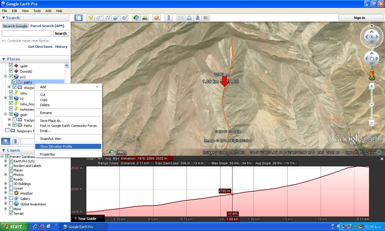 .
.
ارتباط SDI با GIS

SPOT 6
Launched in September 2012, SPOT 6 is the newest member of the SPOT family of satellites to be commercially available. SPOT 6 is an earth observation satellite offering a
Clearinghouse چیست؟
Clearinghouse از مهمترین اجزای زیر ساخت داده های مکانی (SDI) است. در منابع فارسی معادل آن مرکز تبادل داده بیان شده است اما FGDC آن را چنین تعریف کرده است:
A spatial data clearinghouse can be defined (rather verbosely) as "the creation of a centralized or decentralized (distributed) electronically connected network of servers located on the Internet, which contain metadata and detailed catalogue services that are collected in a standard format to facilitate query and consistent presentation across multiple participating sites that band together spatial data providers, custodians and distributors to promote their available digital spatial data and enable all users to search relevant spatial data nodes, determine what spatial data exist, find the data they need, evaluate the usefulness of the spatial data for their applications and obtain or order the data as quickly and economically as possible" (FGDC, 1995).
******************************************************
آموزش انگلیسی
آنهائی که در آموزش زبان انگلیسی کمک لازم دارند این نرم افزار را از سایت زیر دانلود کنند.
*************************************************************
ورتکس و یک Application مخصوص اتوکد
در محیط اتوکد با این Application به راحتی می توانید ورتکس اضافه یا حذف کنید.
یک-جمله
Technology is easy but management is difficult
This was an observation by an eminent scientist during the Earth Observation Systems Forum deliberations at the recently concluded Geospatial World Forum 2012.l.
معرفی نرم افزار
یک مبدل فایل های اتوکد بنام