وبلاگ دکتر علی کلانتری اسکوئی

وبلاگ دکتر علی کلانتری اسکوئی

وبلاگ علمی،آموزشی و خبری در رابطه با سامانه اطلاعات مکانی(GIS)
وبلاگ دکتر علی کلانتری اسکوئی

وبلاگ دکتر علی کلانتری اسکوئی

وبلاگ علمی،آموزشی و خبری در رابطه با سامانه اطلاعات مکانی(GIS)

مطالعه مفهومی ؟

اخیرا در رابطه با مطالعه مفهومی دنبال مطلب بودم که در منابع آموزش و پرورش مطالب خوبی را پیدا کردم. ماحصل کار را در ادامه به اشتراک گذاشتم.


دسترسی آنلاین به میزان انحراف مغناطیسی (Magnetic Declination)

انحراف مغناطیسی بسته به جایی که روی زمین هستید تغییر می‌کند. همچنین در طول زمان در همان موقعیت نیز دچار تغییر می ‌شود، زیرا قطب های مغناطیسی در حال حرکت هستند. البته پیدا کردن انحراف فعلی و صحیح برای هر مکان روی زمین آسان است. فقط به سایت magnetic-declination.com  وارد شوید، سایتی که  با کمک نقشه گوگل از جهان و با یک کلیک میزان انحراف صحیح محل شما را ارائه می‌کند.

 magnetic-declination.com

Find the magnetic declination at your location

More Information

*** انحراف مغناطیسی:

عدم انطباق شمال حقیقی بر شمال مغناطیسی باعث می‌شود که بین این دو امتداد زاویه ای تشکیل شود که این زاویه را زاویه میل/انحراف مغناطیسی می‌نامند. بر حسب آنکه شمال مغناطیسی در شرق یا غرب شمال جغرافیائی قرار گیرد انحراف را شرقی یا غربی گویند. مقدار انحراف مغناطیسی در زمان و در مکان تغییر می‌کند و در عملیات نقشه برداری در وسعت‌های کم از این تغییرات صرفنظر می‌شود.


معرفی اپلیکیشن قطب نما، ترازسنج و GPS

در اپلیکیشن موبایل Compass Level & GPS ؛ ابزارهای قطب نما، تراز و GPS در یک  مجموعه در اختیار کاربر قرار داده شده است.
دوستداران D.I.Y. (do-it-yourself)؛ میتوانند از آن در نصب و تراز کردن وسایل مختلف مثل قرار دادن یخچال، آویزان کردن قفسه یا قاب استفاده کنند. همچنین با این اپ در ردیابی، پیاده‌روی و کمپینگ از مسیر خود خارج نخواهید شد و همیشه موقعیت و جهت درست را دارید. این ابزار مفید و دقیق است - خودتان آن را امتحان کنید!

امکانات:

– نمایش سطح افقی و عمودی به صورت خودکار
– انتخاب صدا و/یا لرزش هنگام تراز شدن
– قطب نما دستی و کالیبراسیون سطح
– دکمه ‘Hold / Release’، برای بازخوانی آسان
– ضبط صفحه نمایش: بدون یادداشت ها، فقط کپی
– حساسیت سنسور و چرخه به روز رسانی
– ویژگی قدرتمند GPS: تعیین مکان هدف، و پیدا کردن جهت و فاصله

----- نکات (قطب نما)
– دقت سنسور بسته به دستگاه مورد استفاده ممکن است متفاوت باشد.
– برای دقت بهتر، از میدان های مغناطیسی و دستگاه های الکترونیکی دور باشید.

دانلود apk برای اندروید

ver 2.4.15


https://play-lh.googleusercontent.com/QOtwnt841UCyDevNa5zC1w1lSobPsLKTQ55haUr39rbzAyR6abHzO5urLK_0Mv4WPzQ=w526-h296https://play-lh.googleusercontent.com/s1_lxaeWeWu2h-XgB-KTYvtvsl-ksq2fNU3zp3Jy3vQdpw8TxCC86nbKPaSrjBtPEMk=w526-h296
https://play-lh.googleusercontent.com/f6AQDoYV-827jEiUF9hMzR5kZQJp4RJ5z59Ra0LC2d237MdbcbzT5AZNDys4tjKE7phK=w526-h296


استخراج داده از اتوکد

AutoCAD Data Extraction

یکی از امکانات ارزشمند در محیط اتوکد (معمولی و Civil 3D) دستور DATAEXTRACTION است. از رایج ترین موارد استفاده این دستور این است که مختصات نقاط وارد شده در اتوکد (x,y.z) را میتوانید به راحتی به صورت فایل اکسل یا تکست ذخیره و یا همان مختصات را بصورت یک جدول به محیط ترسیم اتوکد اضافه کنید. اما ترجمه راهنمای آن:

استخراج داده‌های اتوکد با استفاده از دستور DATAEXTRACTION یا به اختصار DX ، قابلیتی است که داده‌ها را از یک یا چند نقشه اتوکد استخراج کرده و در جدول قرار می‌دهد.  همچنین می توان از آن برای ادغام داده ها از یک فایل خارجی استفاده کرده و  داده ها را در یک جدول قرار داد.

بسته به تنظیمات انتخابی شما، این دستور می‌تواند داده‌ها را در فرمت فایل‌های csv، .xls، .mdb. و txt. ذخیره کند.

به بیان ساده، ویژگی استخراج داده‌های اتوکد، اطلاعات ترسیمی، هندسی (Geometry)، ویژگی‌های بلوک و ویژگی‌های شی را به جدول استخراج داده یا فایل خارجی صادر (Export) می‌کند.  این ویژگی با ساده سازی فرآیند جمع آوری داده ها در زمان صرفه جویی میکند و خطاهای پرهزینه ناشی از ورود دستی داده ها را کاهش می دهد. استخراج داده های اتوکد به طور خودکار مواردی را که با معیارهای خاص مطابقت دارند شمارش می کند؛ این به شما امکان می دهد داده ها را از فایل های خارجی وارد کرده و آنها را در ترسیمات خود ادغام کنید. با این ویژگی  هر بار که طرح را تغییر می دهید، به طور خودکار می توانید محتویات جدول استخراج داده ها را به روز کنید.

نکته: برای استخراج مختصات (x,y.z) فقط تیک Geometry را حفظ کنید.

دانلود راهنما

در ادامه برخی از خروجی های این دستور نمایش داده شده است.


کتاب آموزش ArcGIS Pro

این کتاب ترجمه کارگاه های آموزشی نرم افزار  ArcGIS Pro می باشد.

نویسنده: پروفسور پاول بولستاد Bolstad Paul استادِ دانشگاه مینسوتا Minnesota

مترجم: سید رضا محمدی زاد 

دانلود کتاب


? ChatGPT and this question: How to success in scientific career

:What ChatGPT tells

To succeed in a scientific career, consider these key strategies:
1. Education and expertise: Obtain a strong educational background in your field of interest and continually update your knowledge and skills.
2. Research and innovation: Contribute to your field through original research and innovative ideas, pushing the boundaries of knowledge. 
3. Networking: Build a strong professional network by collaborating with colleagues, attending conferences, and seeking mentors in your field.
4. Effective communication: Develop strong writing and presentation skills to effectively communicate your research findings and ideas.
5. Perseverance and resilience: Research can be challenging, so staying persistent and resilient in the face of setbacks is crucial.
6. Ethical conduct: Uphold the highest ethical standards in your scientific work to build trust and credibility in the scientific community.
7. Collaborate: Seek opportunities to collaborate with other researchers and teams to leverage diverse expertise and resources. 8. Stay updated: Stay current with the latest developments in your field by reading scientific literature and attending relevant conferences and seminars.
9. Seek funding: Learn to write effective grant proposals to secure funding for your research projects and initiatives.
10. Mentorship: Consider seeking mentorship from experienced scientists to gain insights and guidance for your career development. 
* Remember, scientific success often involves a combination of hard work, dedication, and a passion for discovery. Continuously seek to learn, grow, and contribute to the advancement of science.

ChatGPT and this question: How to success in life

What ChatGPT tells:

To find success in life, consider these key principles:
1. Set clear goals: Define what success means to you and set specific, achievable goals to work towards.
2. Develop a growth mindset: Embrace challenges, learn from failures, and continuously seek to improve and grow.
3. Work hard and stay focused: Stay committed to your goals and put in the effort needed to achieve them.
4. Build strong relationships: Cultivate positive relationships with supportive and positive people who can encourage and guide you.
5. Take care of yourself: Prioritize your physical and mental well-being to maintain a healthy balance in life.
6. Stay adaptable: Be open to change and willing to adjust your plans as needed. Remember, success is a personal journey, and it's important to define success in a way that is meaningful to you.
7. Seek continuous learning: Stay curious and open-minded, always seeking to expand your knowledge and skills.
8. Manage your time effectively: Prioritize your tasks and activities to make the most of your time and stay productive.
9. Be resilient: Embrace setbacks as learning opportunities and persist in the face of challenges.
10. Give back: Find ways to contribute to your community or causes you care about, as helping others can bring a sense of fulfillment and purpose. 
* Remember, success is a journey, and each person's path to success is unique. Stay true to yourself and keep working towards your aspirations.

اطلاعیه روز GIS در سال 2023 (By MDPI)

Subject: [IJGI] Discover the Highlights on GIS Day

ijgi-logo

In order to commemorate GIS Day, MDPI is launching a special webinar to encourage scientists to raise awareness about the importance of geography and GIS technology. GIS Day (Geographic Information Systems Day), first held in 1999, is an annual celebration that highlights the significance of geographic information systems (GIS)-based technologies. It was initiated by spatial analytics software provider Esri, and was famously inspired by American activist and lawyer, Ralph Nader. We are very much looking forward to seeing you at the Topics Webinar | EO&GEO Series: GIS Day. You can access an up-to-date outline of presenters here.

After registering, you will receive a confirmation email containing information on how to join the webinar. Registrations with academic institutional email addresses will be prioritized.

Unable to attend? Register anyway and we will let you know when the recording is available to watch.

We also take great pleasure in welcoming you to read and share the featured papers in ISPRS IJGI.

Featured Papers

   
 An End-to-End Point of Interest (POI) Conflation Framework

Raymond Low et al.

 Group-Privacy Threats for Geodata in the Humanitarian ContextM

Brian K. Masinde et al.

 
 Read More ❯❯ Read More ❯❯ 
   
 An Ontology-Based Framework for Geospatial Integration and Querying of Raster Data Cube Using Virtual Knowledge Graphs

Younes Hamdani et al.

 Modelling Global Deforestation Using Spherical Geographic Automata Approach

Bright Addae et al.

 
 Read More ❯❯ Read More ❯❯ 

To access all papers published in the latest issue, please see here.

Call for Papers

Trustful and Ethical Use of Geospatial Data

edited by Maria Antonia Brovelli, Songnian Li and Ivana Ivánová

submission deadline 31 December 2023
Submit Now ❯❯
Unlocking the Power of Geospatial Data: Semantic Information Extraction, Ontology Engineering, and Deep Learning for Knowledge Discovery

edited by Christos Chalkias, Marinos Kavouras, Margarita Kokla and Mara Nikolaidou

submission deadline 15 February 2024
Submit Now ❯❯

Why Submit to IJGI?

 Open Access Unlimited and free access for readers
 No Copyright Constraints Retain copyright of your work and free use of your article
 Thorough Peer-Review
 Rapid Publication A first decision is provided to authors approximately 35.2 days after submission; acceptance to publication is undertaken in 2.9 days (median values for papers published in this journal in the first half of 2023)
 Coverage by Leading Indexing Services Scopus, SCIE (Web of Science), GeoRef, PubAg, dblp, Astrophysics Data System, Inspec, and other databases
 No Space Constraints, No Extra Space or Color Charges No restriction on the maximum length of the papers, number of figures or colors
 Discounts on Article Processing Charges (APC) If you belong to an institute that participates with the MDPI Institutional Open Access Program
 Journal Rank JCR - Q2 (Geography, Physical) / CiteScore - Q1 (Geography, Planning and Development)


Journal Information


ISPRS International Journal of Geo-Information (ISSN 2220-9964) provides an advanced forum for the science and technology of geographic information. 

To submit to the journal click here.

Unsubscribe
Manage your subscriptions

www.mdpi.com
MDPI
www.mdpi.com
St. Alban-Anlage 66, 4052 Basel, Switzerland

Tel. +41 61 683 77 34


Disclaimer: MDPI recognizes the importance of data privacy and protection. We treat personal data in line with the General Data Protection Regulation (GDPR) and with what the community expects of us. The information contained in this message is confidential and intended solely for the use of the individual or entity to whom they are addressed. If you have received this message in error, please notify me and delete this message from your system. You may not copy this message in its entirety or in part, or disclose its contents to anyone.

سایت دانلود آمار هواشناسی رایگان


meteomanz.com


 آمار هواشناسی از سال 2000 تاکنون در این سایت تخصصی ارائه می شود.

منبع: وبلاگ آقای دکتر رسول همتی

pishbin.blogsky.com

دانلود گوگل ارث و گوگل ارث پرو (Google Earth)

در دستگاه های قدیمی اگر درنصب یا اجرای گوگل ارث مشکل دارید  این ورژن ها را امتحان کنید. 

 Download Google Earth 2017

 Download Google Earth Pro 7.3.2  x64

انتقال شماره تماس ها از فایل اکسل به گوشی موبایل

افزودن شماره تماس ها به گوشی موبایل زمانی که قصد دارید در شبکه های اجتماعی (مانند واتس اپ, ایتا, شاد و ...) کانال یا گروه چند ده/صد نفری ایجاد کنید کاری ضروری؛ نسبتا آزاردهنده و زمان بر است. در بیشتر موارد  ایجاد فایل شماره تماس ها در نرم افزار اکسل (MS-Excel) راهکاری مناسب می باشد اما  معمولا انتقال شماره تماس ها از فایل اکسل حاوی متن فارسی به گوشی موبایل با مشکل تغییر یا بهم ریختگی حروف فارسی همراه می‌باشد. اگرچه با خرید برنامه‌هایی آماده می‌توانید بر این مشکل فائق شوید اما در اینجا روشی را معرفی می‌کنیم که می‌توانید بدون هزینه نیازهای خود را رفع نمائید. به طور خلاصه در این روش طی مراحلی فایل اکسل شماره موبایل ها  ابتدا به فرمت CSV و سپس به فرمت VCF ذخیره می‌شوند و در نهایت با انتقال فایل VCF به حافظه گوشی و اجرای (Import) آن اطلاعات اعضای مدنظر به دفترچه تلفن گوشی اضافه می‌شوند.مراحل در فلوچارت زیر نشان داده شده است.

نرم افزارهای مورد نیاز شامل Notepad ،Excel و vCard Wizard هستند. لینک دانلود  vCard Wizard در ادامه ارائه شده است.


دانلود برنامه vCardWizard و راهنمای نصب
در باره VCF
VCF یک فرمت استاندارد ذخیره سازی اطلاعات تماس (ایمیل) است.  فایل‌های ذخیره شده به فرمت VCF فایل‌های متنی ساده هستند که معمولا شامل اطلاعاتی مانند نام مخاطب، آدرس ایمیل، آدرس فیزیکی، شماره تلفن و سایر مشخصات و اطلاعات می‌باشند و به عنوان کارت ویزیت الکترونیکی نیز شناخته می‌شوند. زمانی که از مخاطبین گوشی خود نسخه پشتیبان تهیه می‌کنید، تمامی مشخصات مخاطب‌های شما (Contacts) نیز در قالب یک فایل VCF ذخیره می‌شود.

معرفی اپلیکیشن Maps.me

جایگزینی برای گوگل مپ زمانی که در گوشی خود اینترنت ندارید
رایگان است Maps.me
Maps.me is a mobile app for Android, iOS and BlackBerry that provides offline maps using OpenStreetMap data. It was formerly known as MapsWithMe. In November 2014, it was acquired by Mail.Ru Group and became part of its My.com brand. Wikipedia
Fast, detailed and entirely offline maps with turn-by-turn navigation – trusted by over 140 million travelers worldwide
OFFLINE MAPS
Save mobile data, no internet is required
NAVIGATION
Use driving, walking and cycle navigation anywhere in the world
TRAVEL GUIDES
Save you time planning the trip and never miss an interesting place with our ready-made travel guides. We've partnered with the best travel content creators to build travel guide catalog for hundreds of destinations around the world. Whether you prefer city travel, car trips or outdoor activities you will find a great choice of guides for a perfect journey
INCREDIBLY DETAILED
Directions to points of interest (POI), hiking trails and places missing from other maps
UP-TO-DATE
Maps are updated by millions of OpenStreetMap contributors daily. OSM is an open-source alternative to popular map services
FAST AND RELIABLE
Offline search, GPS navigation along with optimized maps to effectively save memory space
BOOKMARKS
Save locations you love and share them with your friends
AVAILABLE WORLDWIDE
Essential for home and travel. Paris, France? Check. Amsterdam, Netherlands? Check. Barcelona, Spain? Check. New York, Chicago, Florida, Las Vegas, Nevada, Seattle, San Francisco, California, USA? Check! Rome, Italy? Check. London, UK? Check.
TRAFFIC DATA
New online city traffic maps. Check out updates on traffic info and fastest driving routes in 36 countries‌
AND MORE
– Search through different categories e.g. restaurants, cafes, tourist attractions, hotels, ATMs and public transport (metro, bus…)
– Make hotel bookings via Booking.com directly from the app
– Share your location via text message or social media
– When cycling or walking, the app shows whether the way is uphill or downhill
Continued use of GPS running in the background can dramatically decrease battery life

Ref: https://play.google.com/store/apps/details?id=com.mapswithme.maps.pro&hl=en&gl=US

گزارش اقتصاد مکانی کشور هلند

این گزارش  را حتماً بخوانید

NETHERLANDS GEOLOCATION ECONOMY REPORT

Market | Economy | Impact

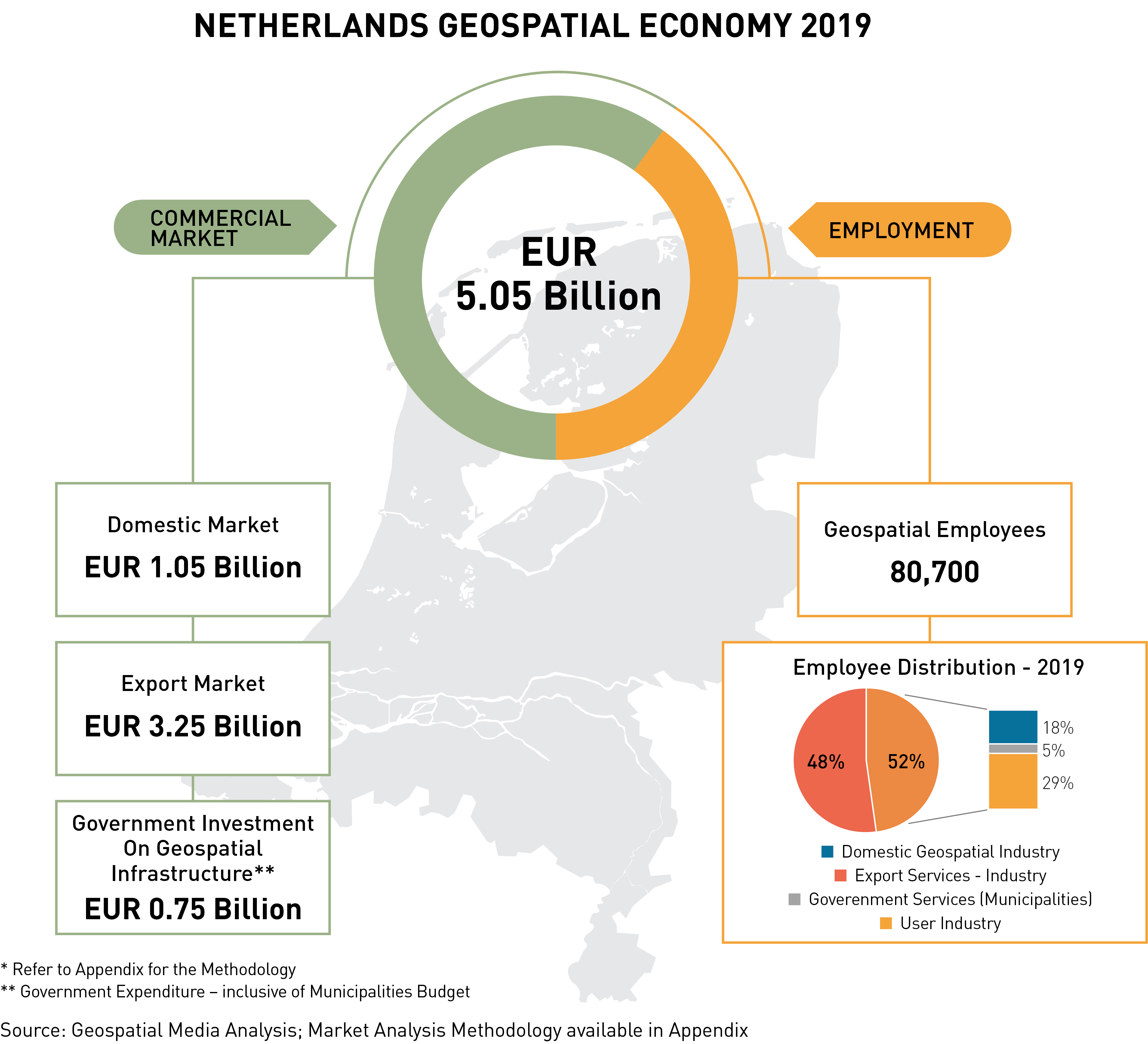
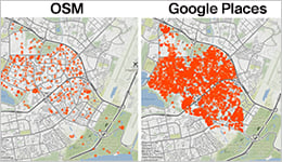
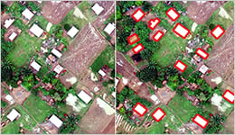
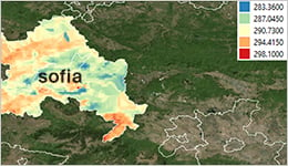
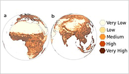
The Netherlands Geolocation Economy report, prepared by Geospatial Media and Communications, in partnership with the Ministry of the Interior and Kingdom Relations of the Netherlands and Geonovum, highlights the value of the geospatial market of the Netherlands and the impact of the same on the country’s economy. The report emphasizes the need for transforming the current geospatial infrastructure model of a country to develop a Geospatial Knowledge Infrastructure (GKI) of tomorrow to integrate geospatial information, analytics, and visualization in order to aid effective decision-making across all sectors. Further, the report also showcases a comprehensive, collaborative, connected and innovative Digital Twin model encompassing engineering and geospatial tools to build a National Digital Twin.

REPORT HIGHLIGHTS:

Netherlands Geospatial Industry: Market Trends and Future Directions

Geospatial Industry Trends and Directions
  • The Netherland's geospatial commercial industry market in 2019 is estimated to be EUR 1.05 billion. The geospatial services industry dominates the market with EUR 528 million market share, i.e., almost 50.2% of the total geospatial market of the Netherlands.
  • The infrastructure sector, which is often known to be a laggard in digitalization, has a significantly higher percentage share of the geospatial market, i.e., EUR 289 million – i.e., 27% of the total market share.
  • Up to EUR 239 million is estimated to be Netherland's geospatial import revenue from the subsidiaries, resellers, suppliers and distributors of the leading geospatial technology providers of the world such as Trimble, Esri, Hexagon, Nvidia, Oracle Spatial, Autodesk, Bentley Systems, among others.
  • Artificial Intelligence (AI), Machine Learning (ML), and the Internet of Things (IoT) are estimated to be the technology game-changer for the Netherlands geospatial industry.
  • The use of geospatial information and technology in the Netherlands is still highly driven by archetypal sectors like Defence and internal security, urban development, infrastructure, disaster management, and governance.

Geospatial – Human Resource Landscape

Geospatial – Human Resource Landscape
  • The Netherlands geospatial industry employs about 80,000 people across the country who specialize in geospatial and geospatial associated technologies.
  • Approximately 18% of the domestic geospatial industry employees are found to have Engineering as their core background specializing in survey engineering.
  • The majority of the geospatial professionals employed in the Netherlands geospatial industry have studied at the Technische Universiteit Delft (TU Delft). The university offers strategic courses in the geospatial sector focused on fundamental geospatial themes –GIS and cartography and 3D modelling, Digital Terrain Modeling (DTM), photogrammetry and 3D computer vision, geomatics, geoscience and remote sensing, and geo-data sets and database management.

The Netherlands Geospatial Economy 2019

In 2019, the Netherlands geospatial economy is valued at EUR 5.05 billion with the domestic market valued at EUR 1.05 billion; export market valued at EUR 3.25 billion and the government investment on Geospatial Infrastructure valued at EUR 0.75 billion.

Economic Impact of Geospatial Technologies and Solutions

Economic Impact of Geospatial Technologies and Solutions

  • The total business impact of the geospatial industry in the Netherlands is presently valued at EUR 31 billion.
  • The estimated consumer benefits basis a “willingness-to-pay” approach in the Netherlands amounts to a combined EUR 4.5 billion per year.
  • The Netherlands geospatial industry employs more than 80,000 people, and the potential employment indirectly linked to the geospatial industry value-chain is over 1.9 million jobs!
  • In comparison to 2019, the use of digital maps has reduced the CO2 emission from vehicular traffic by 18.5%.

Want to know more? Download the free report today and know the in and out of the Netherlands Geospatial Economy!


سه کتاب به وبلاگ اضافه شد


قابل دانلود از بخش  کتب تخصصی